Please find below Mississippi River daily report for May 22, 2025
A Daily Publication of the New Orleans Board of Trade
06:50 hrs. - 05/22/2025
New information (Except for the Air Draft, River Stages, and Vessel Information) is highlighted in Green
General Information: The Controlling Draft for Deep Draft Vessels is 50 Feet. There are four dredges working in Southwest Pass and two dredges working in the crossings above New Orleans.
Bar Pilots High Water Restrictions in Place: Due to severe flocculation Pilots on station are recommending a transit time of 5 hours before to 2 hours after high tide for inbound ships with 38' or greater.
NOBRA Pilots: High Water Restrictions to remain in place until Carrolton Gauge reaches 12 feet and falling.
Mooring/unmooring operations at all mid-stream transfer facilities and any berth that requires the use of a mooring boat along the NOBRA Pilot’s Route shall be restricted to daylight hours.
Pilot Recommendations: Bar Pilots: Recommended maximum loading draft: 50 Feet. Crescent Pilots: Recommended maximum loading draft: 50 Feet. NOBRA Pilots: Recommended loading draft is as follows: 50 feet from New Orleans to Mile 175 ; 47 Feet from Mile 175 - Mile 180; 45 feet from Mile 180 to Mile 234. Vessels with a draft of 41 feet or greater are required to transit the Baton Rouge Harbor (Mile 180 - Mile 234) during daylight hours only.
NOBRA Pilots - High Interest Vessels Vessels classified as HIGH Interest by the Coast Guard, A Federal Authority, Any State Authority, or the NOBRA Board of Directors, may require 2 pilots and be limited to daylight transit only along the NOBRA Route. Any customer of the NOBRA Pilots, docks, berths, moorings, agents, owner, or owner representative may petition the NOBRA Board of Directors to establish or remove the HIV classification. PER THE NOBRA PILOTS, A VESSEL ONLY REQUIRING A CREW CONTROL SECURITY PLAN (CCSP) BY THE COAST GUARD WILL NOT BE SUBJECT TO THE 2 PILOT RULE.
Federal Pilots: Recommended maximum loading draft:50 feet from the Sea Buoy to Mile 175; 45 feet from Mile 175 – Mile 232.4; and 40 feet from Mile 232.4 – Mile 233.8.
Coast Guard Notices: VTS Safety Measure – Neptune Pass Stone Work – MM 23-24, AHP Vessel Traffic Service (VTS) Lower Mississippi River, in accordance with the Navigation Safety Regulations, Code of Federal Regulations Title 33, Subpart 161.11, will establish a series of VTS measures for all waters of the Lower Mississippi River from Mile Marker (MM) 23.0 to MM 24.0, Above Head of Passes (AHP). These measures are needed to protect persons and vessels from the potential safety hazards associated with the work to construct the Neptune Pass Inlet Structure, and are in effect with the following provisions:
Starting on May 5th, 2025, at 6:00 a.m. and continuing through October 5th, 2025: • All vessels shall transit at their slowest safe speed between MM 23 and MM 24. • All vessels shall avoid overtaking or meeting within 1,000 feet of the work barges. • Ostrica Anchorage will be CLOSED for the duration of this work. • These restrictions are in place 24/7.
Work will take place during daylight hours. During working hours, the anchor spread will be extended at a maximum of 600 feet from the Left Descending Bank of the Mississippi River.
CARROLLTON GAUGE AT 15 FEET AND FALLING When the Carrollton Gauge reads 15 feet and falling, the following operating requirements are no longer in effect:
Towing vessels should not transit between two anchored ships.
Towing vessels less than 79 feet in length should maintain a one-foot minimum freeboard at the lowest point. Towing vessels should only operate with less than one foot of freeboard if the vessel’s Safety Management System (SMS) specifically addresses the hazardous conditions associated with high river currents and low freeboard.
Towing vessels should maintain a minimum barge-to-horsepower (HP) ratio of 300 HP per standard barge and 700 HP per oversize barge for downbound transits. Empty barges may be calculated at ½ the horsepower requirements to that of a loaded barge when computing the overall horsepower requirement. Towing vessels with Z-drive propulsion types may be treated as having a horsepower 20% greater than the engine’s rating for the purpose of this calculation. VTS LMR may, on a case-by-case basis, approve exceptions up to 400 HP based on conditions and size of tow. VTS LMR may make horsepower exceptions to allow pushing up to 2 standard barges more than calculated for tows that are fully squared off.
As per 33 CFR 165.803 (b)(3) upbound vessels must be able to make an average of 3 MPH (2.6 knots).
Vessels should maintain a minimum safe distance upriver of stationary objects (such as anchor blocks, midstream berths, etc.) of twice the tow length. If the minimum distance allowed is impracticable, then a second assist vessel should be utilized.
Lite boat vessels engaged in a down streaming maneuver that is greater than 150 feet from a bank shall operate under the following provisions:
Limited to daylight as much as possible.
Rescue vessel should be available during these operations.
Vessel should be 65 feet or greater in length overall (LOA) and at least 1,200 HP.
As per 33 CFR 165.810 (d) (2), vessels are prohibited from entering South Pass (from the Gulf) if the vessel has a speed of less than 10 miles per hour (MPH) (8.7 knots).
A VTS measure may be established prohibiting cargo operations in the anchorages without COTP permission between SWP and mile marker 167.5 AHP (bunkers and ship stores are exempt).
Vessels should be separated by 1,000 feet in anchorages throughout the LMR when practicable.
Lower Mississippi River Bridges Air-Draft Calculations: The above clearances were calculated this morning using gauge readings provided by the Army Corps of Engineers. As a guide the pilots require at least an additional 3 feet of clearance for the Vessel's Air Draft. The individual pilot assigned to the vessel will make the final determination of the vessel's allowable clearance. Actual clearance should be verified when ordering pilot services. NOAA PORTS INFORMATION: To Access the NOAA Ports System for the Lower Mississippi River, go to the following link: http://tidesandcurrents.noaa.gov/ports/index.shtml?port=lm
National Information: Marsec Level – 1
VESSELS SCHEDULED TO ARRIVE IN THE NEXT 24 HOURS:
VESSELS SCHEDULED TO DEPART IN THE NEXT 24 HOURS:
Weather / Marine Zone Forecast
U.S. Corps of Engineers: VELOCITY READING (NEW ORLEANS) 3.6 Knots Mississippi River - Projection- Based off 48 Hours of Forecast Rainfall
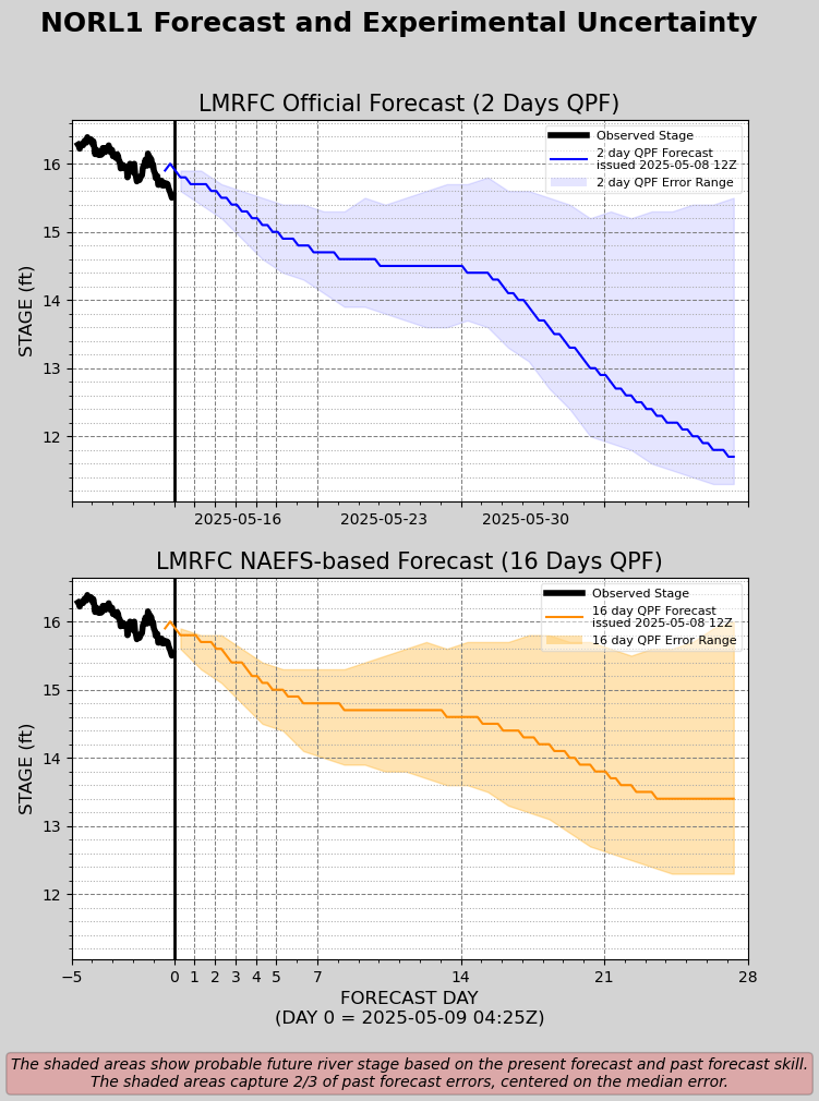
Mississippi River - NOLA Projection- Based off 16 Days of Forecast Rainfall (Experimental)-
Disclaimer: For quality assurance purposes please note well that while the information contained in this website is regularly vetted for accuracy it is not intended to replace the local knowledge or expertise pertaining to port conditions of our marine operations personnel.
Access our team on the go
There are two ways to ensure you can always reach us.
Mobile App
Download our mobile app to search our corporate directory and contact us.
Print Directory
Download and print out our foldable portable directory for quick access.