Port Update
Boston, MA
April 21, 2025
Notices
BOSTON Harbor is at MARSEC Level 1
BOSTON CBP has noted the following:
Crew changes are being permitted. Offsigner flights need to be vetted by CBP in advance.
Shore leave is permitted.
Current Maximum Drafts at Oil Terminals
Current Maximum Drafts at Oil Terminals
***************************************
Citgo Braintree 34-09 Brakish Water
Global Chelsea 32-00 Salt Water
Global Revere 32-00 Salt Water
Global Eastern Ave. 35-00 Salt Water
Irving Revere 36-00 Salt Water
Sprague Deepwater 34-00 BERTH DEPTH, Salt Water
Sunoco East Boston 36-06 Salt Water
TRT Quincy 28-00 Salt Water
McArdle Bridge Update
*********************
The McArdle Bridge is operating on normal
on demand bridge openings for marine traffic.
Chelsea Street Bridge Update
****************************
The Chelsea Street Bridge is operating on normal
on demand bridge openings for marine traffic.
Fore River Bridge Update
************************
The Fore River Bridge is operating on normal
on demand bridge openings for marine traffic.
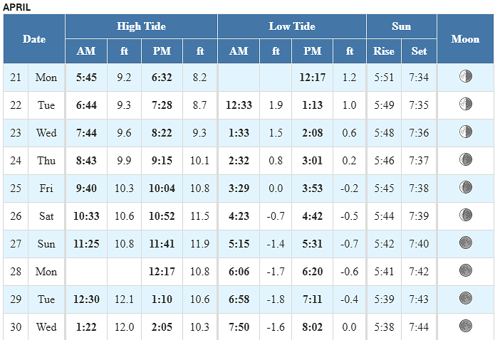
Tides / Currents
Weather / Marine Zone Forecast
Current weather
Mostly Sunny, 44° F
Feels Like 43° F
Today’s High 58° F
Wind, NNW 7 mph
Humidity 38%
Visibility 10.0 mi
Pressure 30.36 in
Some sunshine giving way to clouds.
Synopsis for Massachusetts and Rhode Island coastal waters:
High pres builds over the region today, with a warm front moving
through into Tue. Cold front moves through Tue night with another
high pres arriving for Wed. High pres maintains control through Thu.
Periodic chances for rainfall Fri through next weekend.
Coastal waters east of Ipswich Bay and the Stellwagen Bank National Marine Sanctuary:
.TODAY...NW winds 5 to 10 kt, becoming SE 10 to 15 kt with gusts
up to 20 kt this afternoon. Seas 2 to 3 ft. Wave Detail: N 2 ft
at 5 seconds and SE 1 foot at 7 seconds.
.TONIGHT...S winds 10 to 15 kt with gusts up to 20 kt. Seas 2 to
3 ft. Wave Detail: S 2 ft at 6 seconds and NE 1 foot at
4 seconds. Showers likely after midnight.
.TUE...S winds 10 to 15 kt with gusts up to 20 kt. Seas 2 to
4 ft. Wave Detail: S 3 ft at 4 seconds and SE 1 foot at
10 seconds. Patchy fog. A chance of showers in the morning. Vsby
1 NM or less, increasing to 1 to 3 NM in the afternoon.
.TUE NIGHT...SW winds 10 to 15 kt with gusts up to 20 kt,
becoming NW after midnight. Seas 2 to 3 ft. Wave Detail: S 3 ft
at 5 seconds and W 2 ft at 3 seconds.
.WED...NW winds 5 to 10 kt, becoming S in the afternoon. Seas
2 to 3 ft. Wave Detail: S 2 ft at 6 seconds and SE 2 ft at
9 seconds.
.WED NIGHT...S winds 5 to 10 kt, becoming NW after midnight. Seas
around 2 ft. Wave Detail: SE 2 ft at 8 seconds and S 1 foot at
3 seconds.
.THU THROUGH FRI...S winds 5 to 10 kt. Seas 2 to 3 ft.
.FRI NIGHT...S winds 10 to 15 kt with gusts up to 20 kt. Seas
2 to 4 ft. A chance of showers.
Seas are reported as significant wave height, which is the
average of the highest third of the waves. Individual wave
heights may be more than twice the significant wave height..
If you would like updates for all OR other USA ports, the easiest method for reviewing our daily port updates is by visiting:
Subscribe / Unsubscribe to Daily Port Updates https://www.moranshipping.com/news/subscribers/new
MSA Useful Links
****************
Army Corp of Engineers
Boston Harbor Pilot Association, LLC
NOAA
Chart viewer - handy tool for chart reference
Weather WEB Sites
Please visit our Boston Port site at:
Subscribe / Unsubscribe to Daily Port Updates https://www.moranshipping.com/news/subscribers/new
Daily Update Reference https://www.moranshipping.com/news/bulletins


