Port Update
Boston, MA
May 30, 2025
Notices
BOSTON Harbor is at MARSEC Level 1
BOSTON CBP has noted the following:
Crew changes are being permitted. Offsigner flights need to be vetted by CBP in advance.
Shore leave is permitted.
Current Maximum Drafts at Oil Terminals
Current Maximum Drafts at Oil Terminals
***************************************
Citgo Braintree 34-09 Brakish Water
Global Chelsea 32-00 Salt Water
Global Revere 32-00 Salt Water
Global Eastern Ave. 37-00 BERTH DEPTH, Salt Water
Irving Revere 36-00 Salt Water
Sprague Deepwater 34-00 BERTH DEPTH, Salt Water
Sunoco East Boston 36-06 Salt Water
TRT Quincy 28-00 Salt Water
McArdle Bridge Update
*********************
The McArdle Bridge is operating on normal
on demand bridge openings for marine traffic.
Chelsea Street Bridge Update
****************************
The Chelsea Street Bridge is operating on normal
on demand bridge openings for marine traffic.
Fore River Bridge Update
************************
The Fore River Bridge is operating on normal
on demand bridge openings for marine traffic.
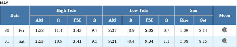
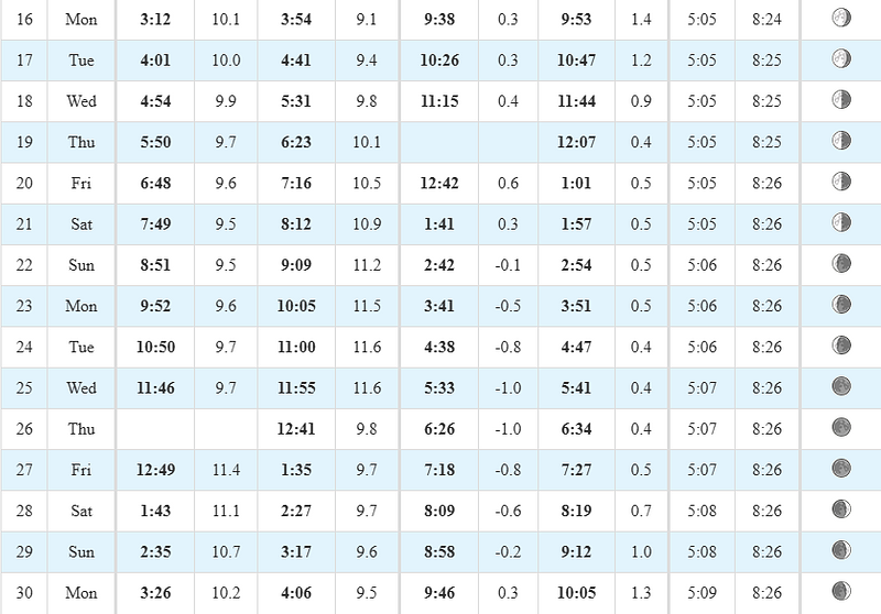
Tides / Currents

Weather / Marine Zone Forecast
Current weather
Mostly cloudy, 61° F
Feels Like 60° F
Today’s High 76° F
Wind, SW 7 mph
Humidity 89%
Visibility 10.0 mi
Pressure 29.75 in
Some sunshine giving way to clouds and warmer with a couple of showers beginning at midday.
Synopsis for Massachusetts and Rhode Island coastal waters:
Another low pressure will track across the region on Saturday,
pushing a cold front across the waters late in the day. High
pressure returns to the waters by Tuesday into Wednesday.
Coastal waters east of Ipswich Bay and the Stellwagen Bank National Marine Sanctuary:
...SMALL CRAFT ADVISORY IN EFFECT FROM SATURDAY MORNING THROUGH
SUNDAY MORNING...
.TODAY...SW winds 10 to 15 kt. Gusts up to 20 kt this afternoon.
Seas 2 to 4 ft. Wave Detail: SE 4 ft at 8 seconds and S 2 ft at
3 seconds. A slight chance of showers this afternoon with vsby
1 to 3 NM.
.TONIGHT...S winds 10 to 15 kt. Gusts up to 20 kt in the evening.
Seas 2 to 4 ft. Wave Detail: SE 4 ft at 8 seconds and S 2 ft at
4 seconds. A chance of showers after midnight.
.SAT...SE winds 15 to 20 kt, becoming S in the afternoon. Gusts
up to 25 kt. Seas 3 to 5 ft. Wave Detail: SE 4 ft at 6 seconds
and SW 2 ft at 4 seconds. Showers likely, mainly in the morning.
Vsby 1 to 3 NM.
.SAT NIGHT...SW winds 15 to 20 kt, diminishing to 10 to 15 kt
after midnight. Seas 3 to 5 ft. Wave Detail: SE 5 ft at 9 seconds
and SW 2 ft at 4 seconds. A chance of showers.
.SUN...SW winds 10 to 15 kt with gusts up to 20 kt. Seas 3 to
5 ft. Wave Detail: S 4 ft at 9 seconds and SW 2 ft at 4 seconds.
A chance of showers in the morning.
.SUN NIGHT...SW winds 10 to 15 kt with gusts up to 20 kt. Seas
2 to 4 ft. Wave Detail: SW 2 ft at 4 seconds and SE 2 ft at
9 seconds.
.MON THROUGH TUE NIGHT...SW winds 5 to 10 kt. Seas 2 to 4 ft.
Seas are reported as significant wave height, which is the
average of the highest third of the waves. Individual wave
heights may be more than twice the significant wave height.
If you would like updates for all OR other USA ports, the easiest method for reviewing our daily port updates is by visiting:
Subscribe / Unsubscribe to Daily Port Updates https://www.moranshipping.com/news/subscribers/new
MSA Useful Links
MSA Useful Links
****************
Army Corp of Engineers
Boston Harbor Pilot Association, LLC
NOAA
Chart viewer - handy tool for chart reference
Weather WEB Sites
Please visit our Boston Port site at:
Subscribe / Unsubscribe to Daily Port Updates https://www.moranshipping.com/news/subscribers/new
Daily Update Reference https://www.moranshipping.com/news/bulletins


