Port Update
RI / Southern Massachusetts
June 09, 2025
Notices
Homeland Security Advisory System
********************************************************************************
The National Homeland Security Advisory System is at Yellow (MARSEC Level I), or an elevated level of threat for the Port of Providence
Local Time Zone
********************************************************************************
The Port of Providence and Narragansett Bay are currently utilizing Eastern Standard Time (GMT -5)
Current maximum drafts at local terminals in feet:
Current maximum drafts at local terminals in feet:
Davisville: 32-00
Provport: 38-00
Hudson: 27-06
ExxonMobil: 38-00
Shell: 40-00
Sprague Providence: 32-00 (Flood tide restricted for berthing)
Sprague East Providence: 32-06 (Daylight & flood tide restricted for berthing)
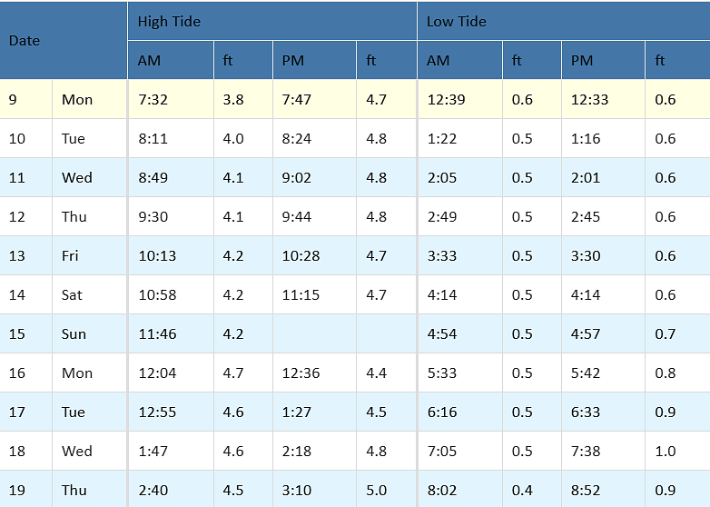
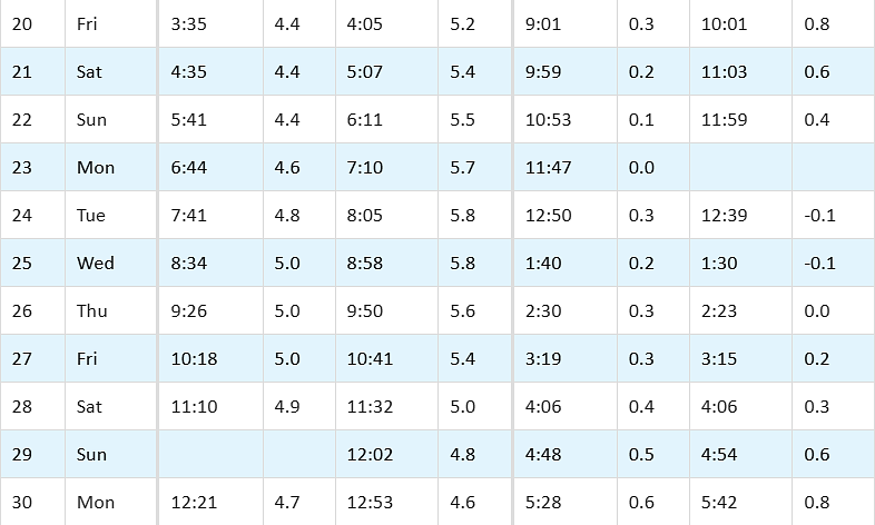
Tides / Currents
Weather / Marine Zone Forecast
Providence, RI Weather
********************************************************************************
Today: A slight chance of showers. Cloudy, with a high near 68. Southeast wind around 9 mph. Chance of precipitation is 20%.
Tonight: A slight chance of showers. Patchy fog after 9pm. Otherwise, cloudy, with a low around 58. East wind 5 to 8 mph. Chance of precipitation is 20%.
Tuesday: Showers likely and possibly a thunderstorm before 2pm, then a chance of showers and thunderstorms between 2pm and 3pm, then showers likely and possibly a thunderstorm after 3pm. Patchy fog before 9am. Otherwise, cloudy, with a high near 73. Southeast wind around 6 mph becoming south in the afternoon. Chance of precipitation is 70%. New rainfall amounts between a quarter and half of an inch possible.
Tuesday Night: A chance of showers, mainly before 10pm. Cloudy during the early evening, then gradual clearing, with a low around 60. West wind 3 to 7 mph. Chance of precipitation is 40%. New precipitation amounts between a tenth and quarter of an inch possible.
Wednesday: Sunny, with a high near 83. Light west wind increasing to 5 to 10 mph in the morning.
Wednesday Night: Mostly clear, with a low around 64. Southwest wind around 7 mph.
Thursday: Sunny, with a high near 85. West wind 8 to 11 mph.
Thursday Night: Mostly cloudy, with a low around 61. West wind 3 to 6 mph.
Friday: Partly sunny, with a high near 78. Northwest wind 3 to 6 mph.
Friday Night: Mostly cloudy, with a low around 56. Light north wind.
Saturday: A chance of showers. Mostly cloudy, with a high near 70. East wind 5 to 7 mph. Chance of precipitation is 30%.
Saturday Night: A chance of showers. Mostly cloudy, with a low around 53. Northeast wind 3 to 6 mph. Chance of precipitation is 30%.
Sunday: A chance of showers. Mostly sunny, with a high near 69. East wind 6 to 9 mph. Chance of precipitation is 30%.
Marine Forecast
********************************************************************************
Narragansett Bay:
This Afternoon: E winds 5 to 10 kt. Waves around 2 ft. Patchy fog. A slight chance of showers. Vsby 1 nm or less.
Tonight: NE winds 5 to 10 kt. Waves around 2 ft. Patchy fog. Vsby 1 nm or less.
Tue: SE winds 5 to 10 kt. Waves around 2 ft. Patchy fog. A chance of showers in the morning, then showers likely with a chance of tstms in the afternoon. Some tstms may produce heavy rainfall in the afternoon. Vsby 1 to 3 nm.
Tue Night: SW winds 5 to 10 kt, becoming W after midnight. Waves 2 to 4 ft. Patchy fog in the evening. A chance of showers in the evening with vsby 1 to 3 nm.
Wed And Wed Night: SW winds 10 to 15 kt with gusts up to 20 kt. Waves 2 to 4 ft.
Thu Through Fri Night: E winds 10 to 15 kt with gusts up to 20 kt. Waves 2 to 3 ft.
********************************************************************************
Rhode Island Sound:
This Afternoon: E winds 10 to 15 kt. Gusts up to 20 kt. Seas 2 to 3 ft. Wave detail: SE 3 ft at 6 seconds and SE 1 foot at 12 seconds. Patchy fog. A slight chance of showers. Vsby 1 nm or less.
Tonight: E winds 5 to 10 kt. Seas 2 to 3 ft. Wave detail: SE 3 ft at 7 seconds and SE 1 foot at 12 seconds. Patchy fog. Vsby 1 nm or less.
Tue: S winds 5 to 10 kt. Seas 2 to 3 ft. Wave detail: SE 3 ft at 7 seconds and SE 1 foot at 11 seconds. Patchy fog. A chance of showers in the morning, then showers likely with a chance of tstms in the afternoon. Some tstms may produce heavy rainfall in the afternoon. Vsby 1 to 3 nm.
Tue Night: SW winds around 10 kt, becoming W after midnight. Seas 2 to 4 ft. Wave detail: S 4 ft at 8 seconds and SE 2 ft at 7 seconds. Patchy fog in the evening. A chance of showers in the evening with vsby 1 to 3 nm.
Wed And Wed Night: SW winds 10 to 15 kt with gusts up to 20 kt. Seas 3 to 4 ft. Wave detail: S 4 ft at 8 seconds and SW 2 ft at 3 seconds.
Thu And Thu Night: W winds 10 to 15 kt. Gusts up to 20 kt. Seas 2 to 4 ft. Wave detail: S 4 ft at 7 seconds and W 1 foot at 3 seconds.
Fri And Fri Night: NE winds 5 to 10 kt, becoming E. Seas around 2 ft.
********************************************************************************
Buzzards Bay:
This Afternoon: E winds around 10 kt. Seas around 2 ft. Wave detail: E 1 foot at 3 seconds and S 1 foot at 7 seconds. Patchy fog. A slight chance of showers. Vsby 1 nm or less.
Tonight: E winds 5 to 10 kt. Seas around 2 ft. Wave detail: E 1 foot at 3 seconds and S 1 foot at 7 seconds. Patchy fog. Vsby 1 nm or less.
Tue: S winds 5 to 10 kt. Seas around 2 ft. Wave detail: SW 1 foot at 2 seconds and SE 1 foot at 6 seconds. Patchy fog. A chance of showers in the morning. Showers likely with a chance of tstms in the afternoon. Some tstms may produce heavy rainfall in the afternoon. Vsby 1 to 3 nm.
Tue Night: SW winds 5 to 10 kt. Seas 2 to 3 ft. Wave detail: SE 2 ft at 7 seconds and SW 1 foot at 3 seconds. Patchy fog in the evening. A chance of showers in the evening with vsby 1 to 3 nm.
Wed And Wed Night: SW winds 10 to 15 kt with gusts up to 20 kt. Seas 2 to 3 ft. Wave detail: SW 2 ft at 4 seconds and SW 2 ft at 8 seconds.
Thu Through Fri Night: E winds 10 to 15 kt with gusts up to 20 kt. Seas 2 to 3 ft. Wave detail: SW 2 ft at 4 seconds and SE 2 ft at 7 seconds.
********************************************************************************
Cape Cod Bay:
This Afternoon: E winds 10 to 15 kt with gusts up to 20 kt. Seas 2 to 3 ft. Wave detail: SE 2 ft at 6 seconds and E 1 foot at 3 seconds. Patchy fog. A slight chance of showers. Vsby 1 nm or less.
Tonight: E winds 10 to 15 kt with gusts up to 20 kt, becoming SE 5 to 10 kt after midnight. Seas around 2 ft. Wave detail: E 1 foot at 3 seconds and SE 1 foot at 6 seconds. Patchy fog. Vsby 1 nm or less.
Tue: S winds 5 to 10 kt. Seas around 2 ft. Wave detail: E 2 ft at 4 seconds and S 1 foot at 2 seconds. Patchy fog. A chance of showers in the morning. Showers with a chance of tstms in the afternoon. Some tstms may produce heavy rainfall in the afternoon. Vsby 1 to 3 nm.
Tue Night: SW winds 5 to 10 kt, becoming W after midnight. Seas around 2 ft. Wave detail: SE 2 ft at 6 seconds and SW 1 foot at 2 seconds. Patchy fog in the evening. Showers likely in the evening with vsby 1 to 3 nm.
Wed And Wed Night: SW winds 10 to 15 kt with gusts up to 20 kt. Seas around 2 ft. Wave detail: SE 2 ft at 7 seconds and W 1 foot at 2 seconds.
Thu Through Fri Night: E winds 10 to 15 kt with gusts up to 20 kt. Seas around 2 ft. Wave detail: W 1 foot at 3 seconds and SE 1 foot at 6 seconds.
Port / Terminal Restrictions
Cape Cod Canal Draft Restriction
********************************************************************************
The US Army Corp of Engineers has advised that the current maximum air draft for Cape Cod Canal transits remains at 135 feet. Max draft in the canal is currently 30 feet. Vessels with drafts over 28 feet will need a tide window for transit
Cape Cod Canal Transit Restriction
********************************************************************************
None at the moment
********************************************************************************
Please visit our Providence Port site at: http://ri.ports.moranshipping.com/default.aspx


